
At first glance, what remains of the Desjardins Canal in Hamilton reveals little of the ambitious engineering project that once existed here. Yet this largely forgotten waterway has a fascinating history filled with ambitious visions, tragedy, rivalry, and short-lived success. Today, the few surviving landmarks offer a glimpse into this history and the important role the canal once played in the development of transportation in Southern Ontario.
The Desjardins Canal was constructed to establish a navigable connection between Lake Ontario and the growing community of Dundas. From Lake Ontario, vessels would enter Hamilton Harbour before passing through Burlington Heights, a large natural barrier separating the harbour from Cootes Paradise. From there, the canal continued through marshy wetlands, following the course of a small river before finally reaching Dundas. Considered an engineering marvel in its day, the canal was built with the ambitious goal of helping Dundas compete with the rapidly growing community of Hamilton to become the region’s commercial and industrial centre. While the canal would enjoy several years of success, its construction came at a terrible cost, and ultimately, it could not compete with the larger and deeper harbour found in Hamilton.

Dundas and Richard Hatt’s Vision
The first European settlers in the area were drawn to the Dundas Valley because it was one of the few places where the topography allowed relatively easy access up and down the Niagara Escarpment. The many rivers flowing through the valley also provided opportunities to harness waterpower to operate mills and machinery in factories. These geographical advantages helped quickly establish Dundas as an important commercial centre in the region.
One of these early settlers was the prominent political figure and businessman Richard Hatt. After establishing what would become known as the Red Mill in Ancaster, Hatt purchased land in Dundas in 1800 with the ambition of constructing a flour mill.
Three Barriers to Navigation
Hatt’s business endeavours soon opened his eyes to the problems associated with shipping goods and supplies to and from the community. There were three geographical barriers in particular that posed significant challenges to transportation.

Burlington Beach
First, Burlington Beach created a barrier between Hamilton Harbour and Lake Ontario. This naturally formed bayhead bar contained a shallow opening that could be traversed by small boats but prohibited the passage of larger ships. Because of this, cargo was required to be unloaded at the beach, carried across the bar, and loaded onto another vessel before continuing its journey across the harbour.

Burlington Heights
The second barrier was Burlington Heights, a ridge of sand and gravel deposited during the last ice age that separates Cootes Paradise from Hamilton Harbour. The only water route around it was a shallow river winding past its northern end. Construction of the railway and, later, Highway 403 has since cut off this passage.

Cootes Paradise
Lastly, the marshy wetland known as Cootes Paradise posed problems for shipping because of its shallow depths, dense aquatic vegetation, and large quantities of floating debris and fallen trees that were known to obstruct its waters.

Hatt’s Early Waterway Improvements
But these barriers did not halt Hatt’s vision of constructing a navigable waterway through the area. In 1804, he was granted permission to build warehouses on Burlington Beach and in Cootes Paradise to aid in transferring cargo across the barriers. Around the same time, Hatt also deepened the shallow outlet through Burlington Beach and began dredging and clearing Spencer Creek of debris. The largest of these endeavours took place in 1809, when a crew was hired to dredge Spencer Creek from the marsh to Hatt’s wharf in Dundas.
As the War of 1812 came to an end, an influx of settlers began arriving in the region. While Hamilton had a clear advantage in becoming the industrial and commercial centre of the region because of its large, deep harbour, Dundas was already an established commercial district and an important gateway over the escarpment to neighbouring towns further inland. This meant that the construction of a navigable canal and an established port at Dundas was becoming increasingly important to the town’s future as a commercial centre, a prospect clearly recognized by Hatt.
Sadly, Hatt passed away in 1819 without ever seeing the true potential of the canal. Nevertheless, his long and successful career and many business endeavours meant that, at the time of his death, Hatt was one of the wealthiest people in Upper Canada.
Pierre Desjardins Takes Up the Vision
Rewind a few years to 1792. A man by the name of Pierre Desjardins, later anglicized to Peter Desjardins, immigrated to Niagara from his home country of France. Desjardins spent a number of years working various jobs in the Niagara region before becoming a clerk for Richard Hatt in 1812.
Desjardins worked for Hatt until the latter’s death in 1819, after which he not only inherited Hatt’s ambition to construct a canal and place Dundas on the map, but also acquired much of Hatt’s property and facilities along the Dundas waterfront.
Construction, Financial Struggles, and Personal Loss
Desjardins’ shared ambition with Hatt helped him obtain a royal charter in 1816 to begin dredging a canal between Lake Ontario and Dundas. This time, the work involved more than crews of labourers dredging the canal by hand, with advanced machinery and steam-powered dredges also employed.
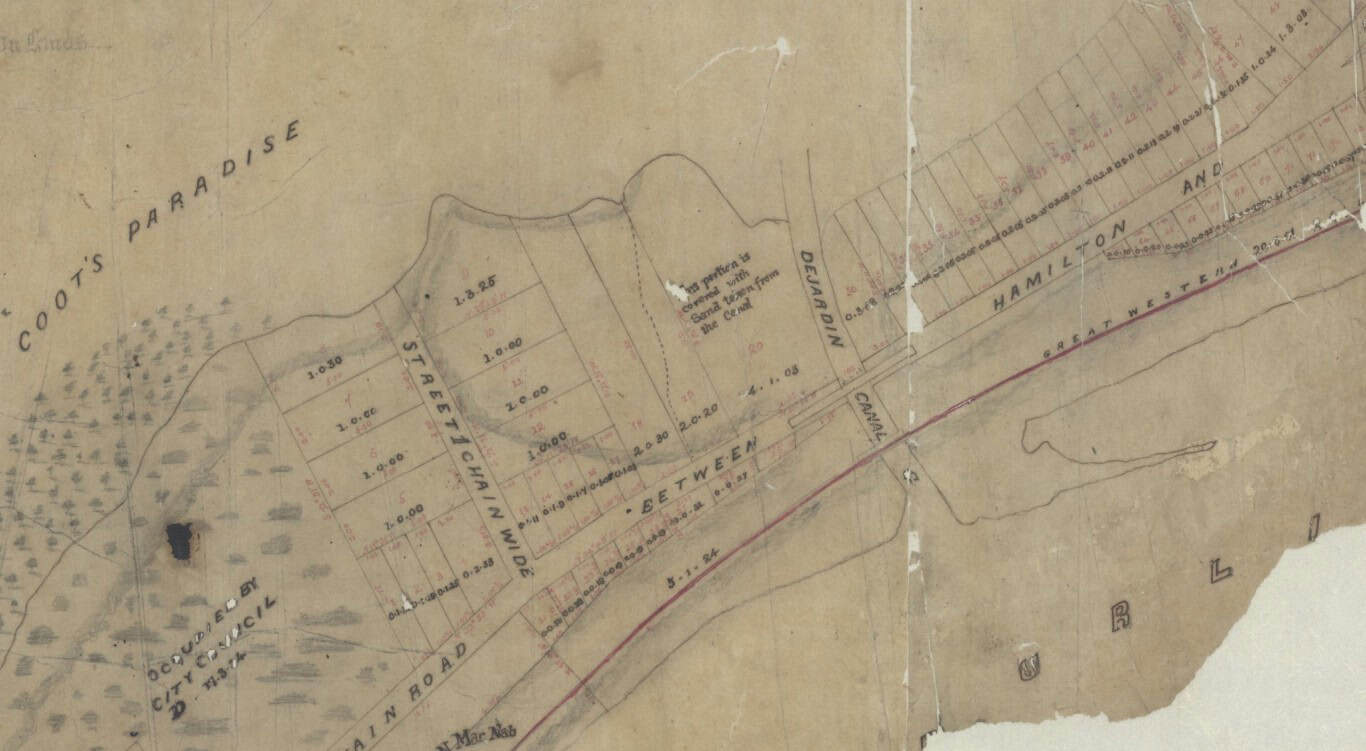
Work on the canal continued, but over time, financing the project became increasingly difficult. Desjardins’ relentless petitioning of the government and years of working to build support for the project kept construction moving forward, although progress remained slow.
Then, in 1826, after recognizing the commercial and military benefits of improving access between Hamilton Harbour and Cootes Paradise, an act of Parliament granted $100,000 to complete the project through a joint-stock company named the Desjardins Canal Company.
By this point, however, the canal had already come at a considerable personal cost to Desjardins, who had even been forced to offer his own house and land to keep the project going.
Tragically, once again, the man behind the vision would never live to see his dream become a reality. On September 7, 1827, Desjardins died in an accident near Grimsby. He was only 52 years old.
A Working Waterway to Dundas
Construction continued until 1837, when the canal was finally completed. Just as Hatt and Desjardins had imagined, Dundas and its industries began to flourish. Steamers and sailing vessels regularly made trips along the canal, helping the town’s many businesses import and export supplies and cargo.
The completed waterway provided improved access from Lake Ontario to Hamilton Harbour through a dredged passage at Burlington Beach. Before its construction, only small boats could pass through the natural opening, but now larger supply ships could safely navigate the barrier, providing access to the Hamilton and Dundas waterfronts. Today, this passage continues to accommodate ships and remains vital to supporting Hamilton’s well-known industrial sector.
After crossing Hamilton Harbour, small ships had originally been able to navigate around Burlington Heights by following a shallow, marshy river that wound its way around the northern end of the ridge. But during the construction of the Desjardins Canal, it was decided that the best route was to excavate a channel directly through the ridge.
This was a massive undertaking, requiring enormous quantities of earth to be excavated and removed. Today, this impressive channel remains one of the most significant reminders of the canal’s history and can easily be explored by walking along the Waterfront Trail and Desjardins Recreational Trail.
From here, the canal route continued across the wetland known as Cootes Paradise before making a slight turn towards Dundas. While the shallow wetland meant that portions of the route required relatively little excavation, aquatic plants and floating debris regularly had to be removed to prevent damage to boats travelling through the waterway.
To help ships navigate the remaining section, a straight canal was excavated and dredged from the open waters of Cootes Paradise to the town of Dundas. At its terminus, a wide turning basin was constructed, providing enough room for ships to turn around and dock along the adjacent wharves.
Today, much of this section of the canal has been buried or bisected by roadways that have filled in significant portions of the original waterway. The canal’s terminus, including its turning basin, has also been filled in and transformed into Centennial Park, where a historical plaque marks its significance.

Railway Competition and the Canal’s Decline
With the exception of several instances when water levels became too low to allow the passage of heavily loaded ships, the canal operated successfully until shortly after the middle of the nineteenth century.
During this time, the Great Western Railway was constructed through the area, connecting Hamilton and Dundas and providing a quicker and more reliable means of transporting cargo to nearby cities. This, combined with the deeper and larger port in Hamilton, gradually diminished the canal’s commercial importance and eventually contributed to its bankruptcy in the early 1870s.
While the canal continued to be used briefly to float logs into Cootes Paradise and Hamilton Harbour, its primary purpose had come to an end, and with it, an important era in local history.


Tracing the Canal Today
Today, with the exception of the passages through Burlington Beach and Burlington Heights, both of which remain in use, much of the Desjardins Canal is hidden in almost every sense of the word.
While the canal was still operating, its route could be clearly distinguished as it passed through Burlington Heights and continued across Cootes Paradise. Through the wetland, the canal was marked by the absence of aquatic vegetation that periodically covered much of the surrounding shallow water. Farther inland, this outline eventually transformed into clearly distinguishable berms built from the deposition of material dredged from the canal.
While still widely considered one of the best places to experience nature in this heavily urbanized region, Cootes Paradise has been significantly influenced by surrounding development and human activity. But urbanization is not the only force that has shaped the canal. Efforts to remediate the area and return portions of the wetland to a more natural state have also contributed to its changing appearance.
River stabilization, plant and wildlife conservation, and the promotion of wetland growth have greatly helped restore this heavily impacted natural environment. However, one unintended consequence of these efforts has been the gradual disappearance of the canal’s remaining physical features.
The creeks and rivers that once formed the basis of the canal have since taken new routes through the Dundas Valley and Cootes Paradise. Today, few sections still flow through the old canal, with much of the water redirected along the northern side of Cootes Paradise. Best seen from the water or while walking along the Royal Botanical Gardens’ trails, a line of old willow trees continues to mark portions of the canal’s former banks.
Closer to the town of Dundas, part of the canal has been preserved and is now used as green space surrounded by parks and walking trails. The terminus of the canal can be found at Centennial Park, where the former turning basin has been filled in, leaving behind a grassy field. Among the many things to see here is a historical plaque marking the significance of Richard Hatt’s and Pierre Desjardins’ ambitious canal.
Although much of the original waterway has disappeared beneath roads, parks, and restored wetlands, the remaining landscape continues to tell the story of an ambitious engineering project that once promised to transform Dundas into one of the region’s most important commercial centres.
Sources
Forsyth, B. (2019). Ghosts of the past – Abandoned shipping canals in Ontario and Quebec. MilitaryBruce.com. https://militarybruce.com/ghosts-of-the-past-abandoned-shipping-canals-in-ontario-and-quebec/
Hamilton Spectator. (2017, June 23). The Frenchman’s dream: A water route to Dundas. https://www.thespec.com/news/2017/06/23/the-frenchman-s-dream-a-water-route-to-dundas.html
Hamilton Historical Board. (n.d.). Historical board report [PDF]. City of Hamilton. http://www2.hamilton.ca/nr/rdonlyres/c8dafef2-9d53-4738-aa03-1e9c0d202323/0/oct21item81hamiltonhistoricalboardreport09002.pdf
McMaster University Library. (n.d.). Desjardins Canal plan [Historical map]. McMaster University Digital Archive. https://digitalarchive.mcmaster.ca/islandora/object/macrepo%3A76562


