Trout River is small, sheltered cover on Newfoundland’s west coast. The town gets its name form the small river that flows through its center, allowing water to pass between Trout River Pond and the Gulf of St. Lawrence. But while this popular tourist destination is known for its outdoor potential, not many people think to paddle the river. But despite a complete lack of information on the paddle we figured the short three-kilometer river would be an easy afternoon adventure.
We launched from the parking lot alongside Trout River Pond. Launching from the small day park was simple because the lake front was almost entirely a gravel beach. Once on the water we decided to paddle along the shore before beginning the short river paddle. There are two things to watch for when launching. Firstly, Trout River Ponds location amongst the mountains means that weather, wind, and wave conditions can change very fast. Trout River Pond is known locally for its treacherous conditions caused by the ponds alignment with prevailing winds that sweep off the mountains.

The second hazard to watch for is the current at the entrance to the river. A strong current is formed from the sudden narrowing of Trout River Pond before it drains through Trout River. Launching to close to the rivers entrance, especially during high water levels can cause you to get caught in the current.
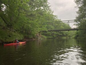
It didn’t take long paddling on the lake before the wind came up and we decided to begin down the river. As you enter the river, the force of the current becomes clear and quick attention must be paid as you travel beneath the bridge and immediately encounter the first bend. Low lying vegetation and trees along the river’s banks become hazardous as your boat will naturally want to sweep along the outside corner of the bend.
Aside from a couple sweeping turns the river is relatively safe. For better or for worse, the river is also shallow and while there are few large rocks in the river, the coarse material that makes up the riverbed means during lower water levels you may be shuffling your boat along the bottom after running aground. This was certainly the case when we went down. Once or twice we even had to get out of our kayaks and move them to a deeper section of the river.
With the exception of a few shallow sections, the river was relatively easy going but the rivers sweeping turns, a couple of side routes, and the scenic contrast of cliffs on your left and small grassy fields on your right, quickly made the trip worthwhile.
One stop that must be made while traversing the river is about 900 meters downstream stay left and you will enter a small side channel. While the entrance is shallow, once you are in the channel it is easy going with fun, sweeping curves and a small rocky beach found at the base of a beautiful waterfall. A glimpse of this unnamed brook and waterfall can be seen from the road but there is no better way to experience it than directly underneath it. We stopped here for a few minutes but dimming daylight meant it was not long before we were back on the water.

From here the river was relatively straight forward. Once you begin to get closer to the ocean, you will enter into “downtown” area of trout river and soon fishing shacks and boats lines the sides. The river’s current dies out unexpectedly as the water level reach sea level. It was this that likely drew the first settlers to the area. Because of the lower river’s depth, large vessels are able to take shelter on the river from the unforgiving Gulf of St. Lawrence.

As you round the final bend of the river, your proximity to the ocean will become clear. Winding around the turn you will quickly hit the swells and waves that permanently resonate off the water and it is now that you will have hopefully taken into account the tides and marine forecast. While Trout River is relatively sheltered, it is still a very active waterfront and a retreating tide mixed with the right offshore wind can prove to be extremely dangerous.
We were lucky in the sense that while we certainly experienced some very large swell, the waves and wind remained low. After paddling up the beachfront we decided to end our adventure on the sandy beaches of Trout River. The water along the coast of Trout River is relatively deep and shallows quickly. This means that the waves tend to break as soon as the hit the beach which is cause for concern when trying to go to shore on a small kayak, but luckily, we did not have this problem and soon we were back on land.
Distance: 3.1 kilometers
Time: 1 hour (Can be done quicker)
Launch Point: N 49.459457, W 58.119076
End Point: N 49.480585, W 58.128001
Difficulty: Easy but be weary of tides, water levels, and sea conditions


