Höfn
We woke up to clear skies and no wind, a rarity for our trip. Höfn is situated on a small peninsula at the start of the Hornafjörður fjord. The town is backdropped by towering mountains, Vatnajökull, and its many glacial tongues. The town itself encircles a small harbour filled with fishing vessels and trawlers tied to the wharf alongside a large lobster processing plant, the economic hub of the town. Like many towns in Iceland, the community balances tourism and an active fishing industry. Large fish trucks regularly came and went on the quiet streets, which contrasted with the number of tourists and small vehicles parked around the town. One of these small vehicles was our own, as we stopped by the waterside café, Hafnarbuðin, for a delicious breakfast.

The water was calm enough to clearly see the reflections of the trawlers. By this time, we were just 250 kilometers south of the Arctic Circle, and the freezing water temperatures proved it. But despite this, it was hard to get over some of the smaller fibreglass boats in the harbour and how they could ever be deemed safe to take out into the frigid Arctic waters. Much like the larger trawlers, these small boats have long supported the fishery, serving both the commercial export sector and the enduring tradition of subsistence fishing in Iceland’s coastal communities.


Diamond Beach and Jökulsárlón Glacial Lagoon
From Höfn we drove back along the Ring Road (Route 1) 75 kilometers to Diamond Beach and the Jökulsárlón Glacial Lagoon. The area is centered around Jökulsárlón, a glacial lagoon fed by the Breiðamerkurjökull glacier, part of the Vatnajökull ice cap. As pieces of the glacier calve, they release large icebergs into the lagoon, which migrate to the lagoon’s south end where they become bottlenecked into a short, but quickly moving river that discharges into the Atlantic Ocean. At this pinch point, the largest of these icebergs run aground, while the smaller bergs are forced down the rushing water into the sea. As these icebergs reach the ocean surf, they are once again broken down and forced back onto the shore. Scattered across the beach, these crystal-clear pieces of glacier resemble diamonds in the sunlight more than ice, earning the beach its well-known name.
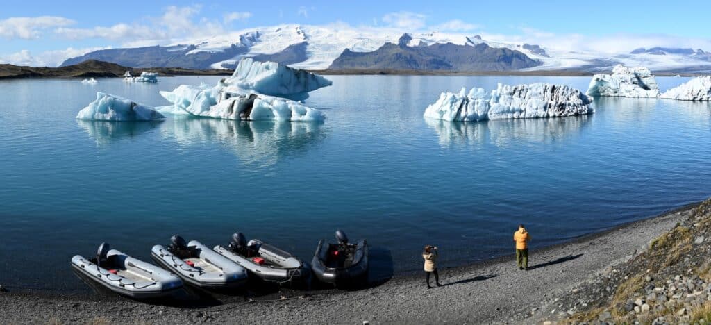
We pulled into the busy parking lot before exploring the beach and then following a well-walked trail under the Jökulsárlón Bridge to the even more popular tourism hub at the south end of the lagoon. Walking along the river, it was shocking to see ice chunks the size of a small house quickly float by. Once we reached the viewpoint for Jökulsárlón, we were greeted by crystal-blue waters dotted with large icebergs, most of which were crossed with dark lines of sediment and ash that had accumulated on the ice before it calved off the glacier in the background. The floating ice giants were not alone in the lagoon—they were joined by kayakers, zodiacs, seals, and amphibious vehicles giving tours to the hundreds of people who visit the site each day. Given the time, we would have done one ourselves, but not wanting to delay, we soon made our way back to the car and continued back towards Höfn.


Stokksnes Peninsula
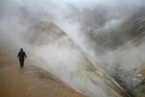
Found across a large inlet from the town of Höfn is the Stokksnes Peninsula. Best known for its black sand dunes and the majestic mountain of Vestrahorn, the rocky headland offers incredible views not only of the surrounding mountains but also of wetlands and seal colonies. After paying a small fee at the Viking Café, we drove across the sandy causeway to the tip of the peninsula and began a short hike to the shoreline and the Stokksnes Lighthouse. Climbing over a small fence used to keep grazing sheep inside, we first made our way to the site of an active radar station owned and operated by NATO.

Known as Stokksnes Radar Station (H-3), the site represents Iceland’s role and strategic location during the Cold War. The high-security station has been active since 2000, though several former radar stations have existed here since the Cold War, the remnants of which can still be found throughout the peninsula. Anyone who knows us will know we have explored our share of abandoned military installations, and as concrete remnants could still be easily seen throughout the fields, we quickly made our way over to explore. The site was without doubt one of the most beautifully placed abandoned places we had ever seen, thanks largely to the backdrop of Vestrahorn rising above the black sand dunes and coastal inlet that surround the peninsula.


After getting our fill of old, decaying foundations, we continued around the peninsula to the Stokksnes Lighthouse. The square tower is perfectly situated at the end of the rocky shoreline, helping sailors navigate the dangerous waters since it was built in 1922. While the seas were relatively calm, they were dotted with seals and seabirds gently floating in the frigid swells.
It was hard to ignore the sharp peaks and towering mountain of Vestrahorn. The famous mountain is one of Iceland’s most popular destinations, a favorite amongst photographers. Composed of some of Iceland’s oldest rocks, its knife-like ridges have given it the unofficial, but appropriate, nickname of “Batman Mountain.” At its base, black sand dunes stretch across the landscape, surrounding a shallow inlet where you are bound to see plenty of migratory birds in the summer.


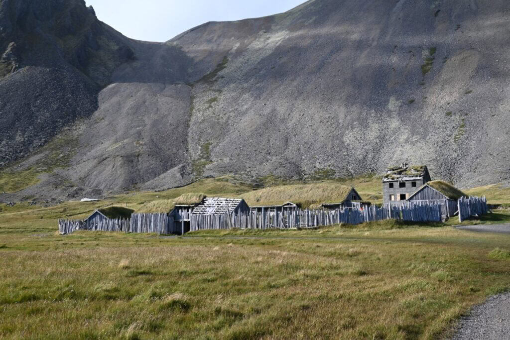
Another site that stands out is found at the base of the mountain: a small, 10th-century village enclosed by a wooden fence, inside of which are several houses, statues, and grass-roofed buildings. Known as Vestrahorn Viking Village, the settlement is actually a film set constructed for an uncompleted movie in the early 2000s. While only a re-creation, it is a perfect example of what a Viking settlement would have looked like, offering a unique way to experience an important chapter of Icelandic history. Since then, the village and surrounding area have been used as a filming location for many movies and shows, most recently recognized for its role in The Witcher TV series.
Eastfjords
Leaving the Stokksnes Peninsula, the road hugs the edge of the mountain until reaching Highway 1. To bypass the Austurhorn range, which contains Vestrahorn, a tunnel known as Almannaskarð was built. Passing through the 1,300-meter tunnel, we began winding our way around the mountains, fjords, and valleys of the Eastfjords. Iceland was formed from the continuous divergence of the Mid-Atlantic Ridge; thus, its western and eastern extremities, such as the Eastfjords, contain some of the oldest rocks in the country, dating back to its formation around 13 million years ago. The mountains of the Eastfjords were created by ancient volcanic activity, but it was periodic ice ages and glaciers that sculpted the incredible landscape found here today. At the base of these mountains, farmland and grazing sheep stretched to the water’s edge, periodically interrupted by small traditional fishing villages, many of which now rely on aquaculture instead of offshore fishing.

Following Highway 1, we decided to take a shortcut through the scenic, unpaved Highway 939. Highway 939 leaves the coastline, tracing the fjord Berufjörður into the highlands. The twisting road was filled with steep drops, switchbacks, and dramatic views. Not something you’d want to do in poor weather, but we were lucky—the skies were clear and the sun was still hovering above the horizon. As we descended into Egilsstaðir, we came across the first trees we had seen in days, and an even rarer sight: deciduous trees. And as it was now September 6 and we were at 65° north, the trees were fully displaying their fall colours. Bright yellows and oranges greeted us as we drove into the hub of eastern Iceland.


Egilsstaðir Camping & Laundry
Our campsite was Camp Egilsstaðir, conveniently located in the middle of town. Within the campground were showers, laundry, a hostel, and even a pub which that night had live music. After setting up camp and cooking supper, we each took turns showering while the rest attempted the long task of doing laundry. We weren’t the only ones with dirty clothes, and because of this the wait for a machine was very long. While we saved a lot of money camping, in hindsight, I do wonder if it would have been better to pay for a more expensive accommodation with laundry to skip the line. Nonetheless, after finally having clean clothes once again, Lindsay and I went into the pub, where we shared a few beers with a group from the United States. The beer must have been good, because before turning in for the night, I managed to snap my phone in half after using it as a flashlight in the rear SUV door. Now with a banana-shaped iPhone, we crawled into our tents and settled in for another chilly night.