The next morning we woke up to blue skies and sunshine, allowing us to take in the beautiful vistas of the surrounding landscape. Our cottage for the night was perched atop a hill overlooking farmland. What made the view even more enjoyable were the sunny skies, clear air, and surprisingly warm temperatures. After having lunch on the patio of Kaffi-Sel Restaurant, and making a quick stop at the liquor store in Flúðir, we began our drive to the backcountry hiking oasis of Landmannalaugar.
Hjálparfoss
Shortly after leaving, we turned east onto Route 32 (Þjórsárdalsvegur), which runs through Iceland’s Þjórsárdalur Valley, home to some of its largest hydroelectric developments. Following the lower stretches of the river Þjórsá, we made our first scenic stop of the day at Hjálparfoss, located on a small tributary of the river.
Hjálparfoss is actually two waterfalls that cascade into a small lagoon, separated by a pillar of dark basalt. The lava flows that created the waterfall, along with the vertical cliffs enclosing part of the lagoon, are comprised of near-perfect hexagonal basalt columns. These formed after a volcanic eruption 8,600 years ago, which produced what is considered the largest lava flow since the last ice age. The Þjórsárhraun lava field covered approximately 960 square kilometers. As the lava cooled, the surface solidified much faster than the interior. This uneven cooling caused the surface to shrink, forming polygon-shaped cracks that extended deep into the rock. Over time, the river eroded the basalt, leaving behind a striking backdrop for the waterfall and exposing the uniquely textured rock faces.


Búrfell
From Hjálparfoss we glimpsed Búrfell Power Station, Iceland’s second-largest hydroelectric plant. Commissioned on September 16, 1969, Búrfell is one of seven hydropower stations in the Þjórsá region. Continuing inland through Þjórsárdalur Valley, we passed reservoirs and canals belonging to the same system.
Most of Iceland’s electricity comes from hydro and geothermal energy, but given the country’s obvious wind potential, we were surprised to find only two turbines operating at the time. Known as the Hafið Wind Farm, these 900 kW turbines sit atop the plateau and were, at the time of our visit, the only ones in Iceland. They will soon be joined by larger onshore and offshore wind farms currently under development.
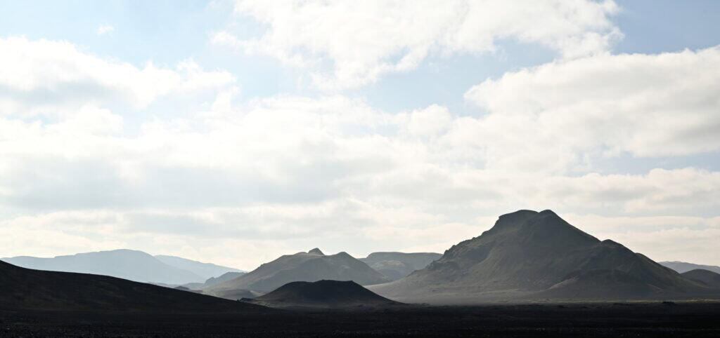
Continuing through the Thjórsárdalur Valley, we ascended a series of terraces, each impounded by its own reservoir and hydroelectric station. Around these artificial lakes, the land stretched out in stark contrast—flat expanses punctuated only by the occasional rolling hill. Not a tree was visible, and the only features breaking the horizon were distant peaks and sharp, cone-shaped volcanic mountains encircling us on all sides.
At our highest elevation, we left Highway 26 and turned onto Highway 208. The broad gravel road began as an access route to the upper hydroelectric works, but it soon narrowed, giving way to the raw character of Iceland’s interior. Here the landscape transformed—the flat terrain dissolving into a labyrinth of jagged lava fields, the road twisting and weaving through the black, contorted remnants of ancient eruptions.
Sigöldufoss
Before reaching this section of the road, we stopped briefly at Sigöldufoss. Though not among Iceland’s largest waterfalls, its setting was striking—and quiet. Here we could drive right up to the rim of the canyon into which the water plunged. Being further from the Ring Road, there was a noticeable absence of crowds and the usual tourist infrastructure: no boardwalks, no signs, no restrooms, and no paid parking lots. Instead, we were immersed once more in the stillness of Iceland’s interior, remote and pristine.
The falls lie on the Tungnaá River, though their flow today is no longer natural. Much of the river has been diverted through the hydroelectric system that dominates this part of the highlands. What remains at Sigöldufoss is the controlled spillway, tumbling over dark basalt cliffs—an elegant reminder of how Iceland’s volcanic landscapes and modern engineering are now interwoven.
Sigöldugljúfur
A short distance further lies Sigöldugljúfur, the spectacular canyon nicknamed the “Valley of Tears.” Cutting through the flat highlands, the canyon is lined with countless waterfalls. Along its southern side, water has pooled to nourish moss and bright green vegetation, contrasting vividly with the dark lava walls.

The setting—surrounded by layered lava flows and plateaued terrain—felt almost surreal. We quickly agreed with others who describe it as one of the most beautiful places in Iceland. While that may sound bold, the warm weather likely helped sway our opinion; it was the first time we were comfortable in t-shirts. Still, with the September sun hanging low, much of the canyon remained in shadow, making it difficult to capture in photos. Even our drone couldn’t quite convey its scale or vibrancy.

Drive to Landmannalaugar
Leaving Sigöldugljúfur, the road to Landmannalaugar narrowed and twisted, loosely following a transmission line out of Þjórsárdalur Valley. The chaotic routing owed to jagged lava fields, which the road wound around and through. Dust kicked up from passing 4x4s and the occasional tour bus only made the drive more challenging. The further we drove, the more alien the landscape became. Jagged ridges, extinct volcanic craters, and mountains dominated the approach to Landmannalaugar.


Landmannalauger
Eventually we entered an enormous river valley carved during the last ice age, perfectly flat at its base but flanked by steep-sided mountains. This marked the start of the Fjallabak Nature Reserve, at the heart of which lies Landmannalaugar. After bravely driving our Dacia Duster through one river, we lost our nerve at the second crossing and instead parked before walking the short boardwalk into base camp.
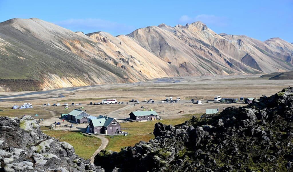
Base camp buzzed with energy: off-road vehicles, colorful tents, hikers from around the world cooking meals, and others heading to the thermal river for a soak.
Landmannalaugar sits at the confluence of three glacial rivers and is surrounded by rhyolitic mountains whose colorful slopes make the area world-famous. Like Kerlingarfjöll, however, its true character lies in its volcanic activity. Hot springs, steam vents, and lava flows dominate the landscape. One of the three valleys that converge here is now completely blocked by a nearly vertical “dam” of black, jagged rock—the Laugahraun lava field. Formed during an eruption of the Torfajökull volcanic system in 1477, the lava was unusually high in silica, making it thick and viscous. The result was a dense, confined flow that now marks the starting point of several popular hikes.


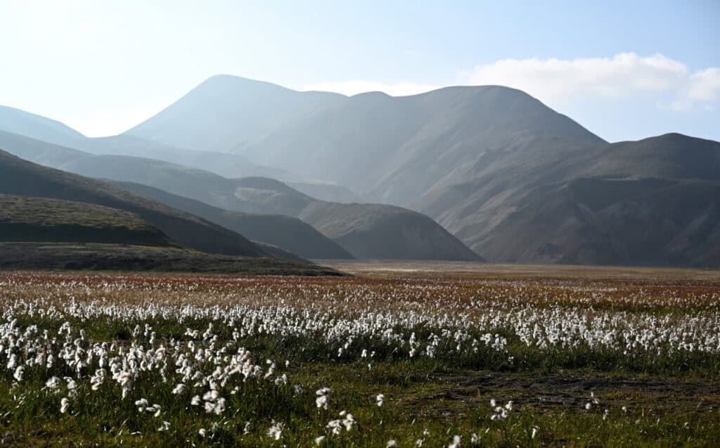
Though arriving later than planned, we managed a 4.5 km loop through the Laugahraun lava field. The scenery shifted dramatically: weaving between black basaltic towers, climbing onto the lava surface, crossing grassy meadows dotted with Arctic cottongrass and sheep, then ascending past steaming vents before returning via the river. For a relatively short hike, it was one of the most varied and unique we had ever done.
As the sun set, base camp was alive with activity—campfires, supper preparations, and laughter in dozens of languages. We had intended to camp, but the exposed site, high elevation, and forecast of below-zero temperatures made us reconsider. Wanting to be rested for the start of our Ring Road journey the next day, we opted instead for a long drive back to lower ground.
Night
By nightfall we finally made it to our campsite at Árnes, which like many Icelandic campgrounds, is basically self serve – find a spot and pay in the morning if you need to. After cooking up a quick supper, we gazed at the endless stars for a while before turning in for the night as the temperatures continued to drop.